How big a square fits inside each US state? Which states fit inside which other states? They sound like quick questions, but the Earth is curved and slightly squashed, so every answer here is worked out on its real shape (the WGS84 ellipsoid), using the Census Bureau’s state boundaries. The code, the method and every number are on GitHub.
It all started with a Terrible Maps post on Instagram showing the biggest square in each of the lower 48 states, none of them turned. If a square could turn, wouldn’t some states fit a bigger one? They would: 22 states’ squares grow by a mile or more.
Click any picture for the full-size version.
The biggest square in each state
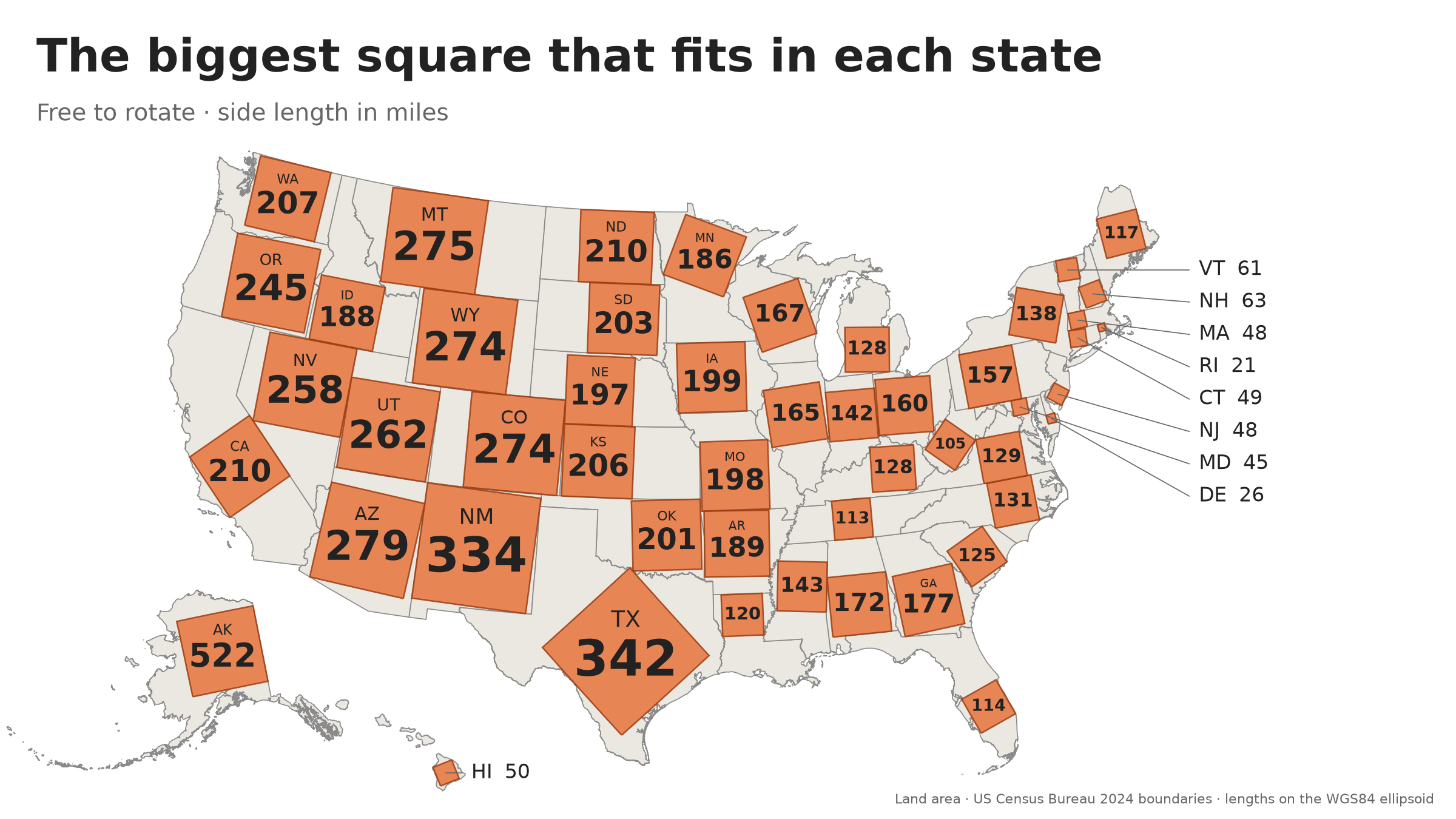
Each square is a true square, as big as it can be while staying inside its state, turned whichever way works best. Alaska’s is 522 miles on a side; Rhode Island’s is 20.6. The search finds the best square, not just a good one, to within a few tens of feet.
Does turning help?
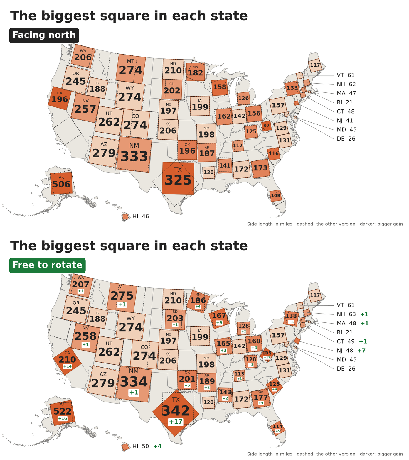
Squares that must face north, then squares free to turn. Darker squares gain more by turning: Texas’s grows by 17 miles when it turns 43.6°, to 341.8 miles. That overtakes New Mexico’s 333.9: facing north, as in the post, New Mexico has the biggest square in the lower 48, but turned, Texas does.
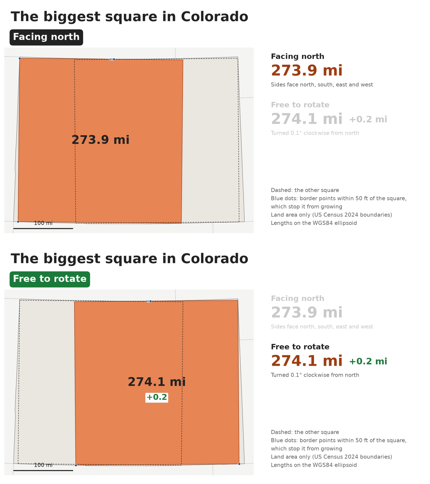
Colorado’s square gains only 0.2 miles by turning, but it moves 94 miles. Colorado’s borders run so close to east-west and north-south that a square as tall as the state fits almost anywhere along it, and tiny wobbles in the surveyed borders decide where the very best one goes.
Seventeen squares
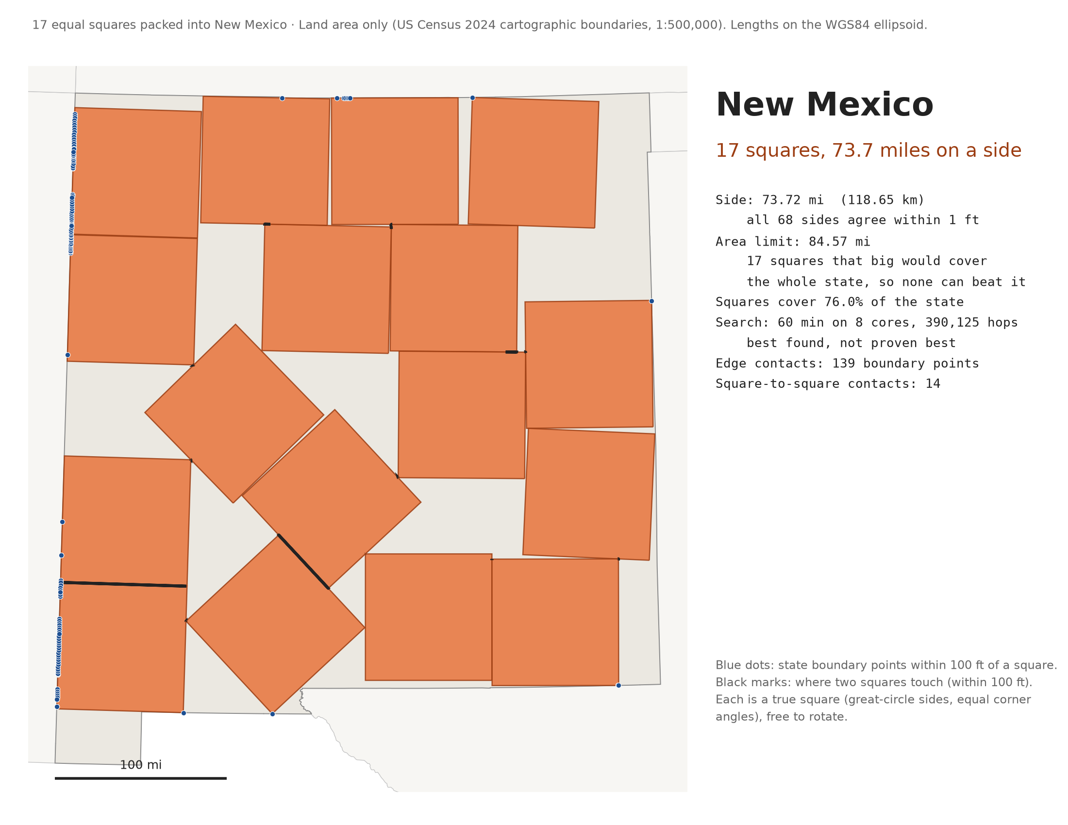
Sixteen equal squares pack neatly into a bigger square. The best known way to fit seventeen is a lopsided jumble that went viral in 2021, and again in 2023, as “ugly math”. Here is the same puzzle for a state: an hour’s search packed 17 squares, each 73.7 miles on a side, into New Mexico. That beats the 71.4 miles you’d get by shrinking the famous jumble to fit New Mexico’s biggest square.
States inside states
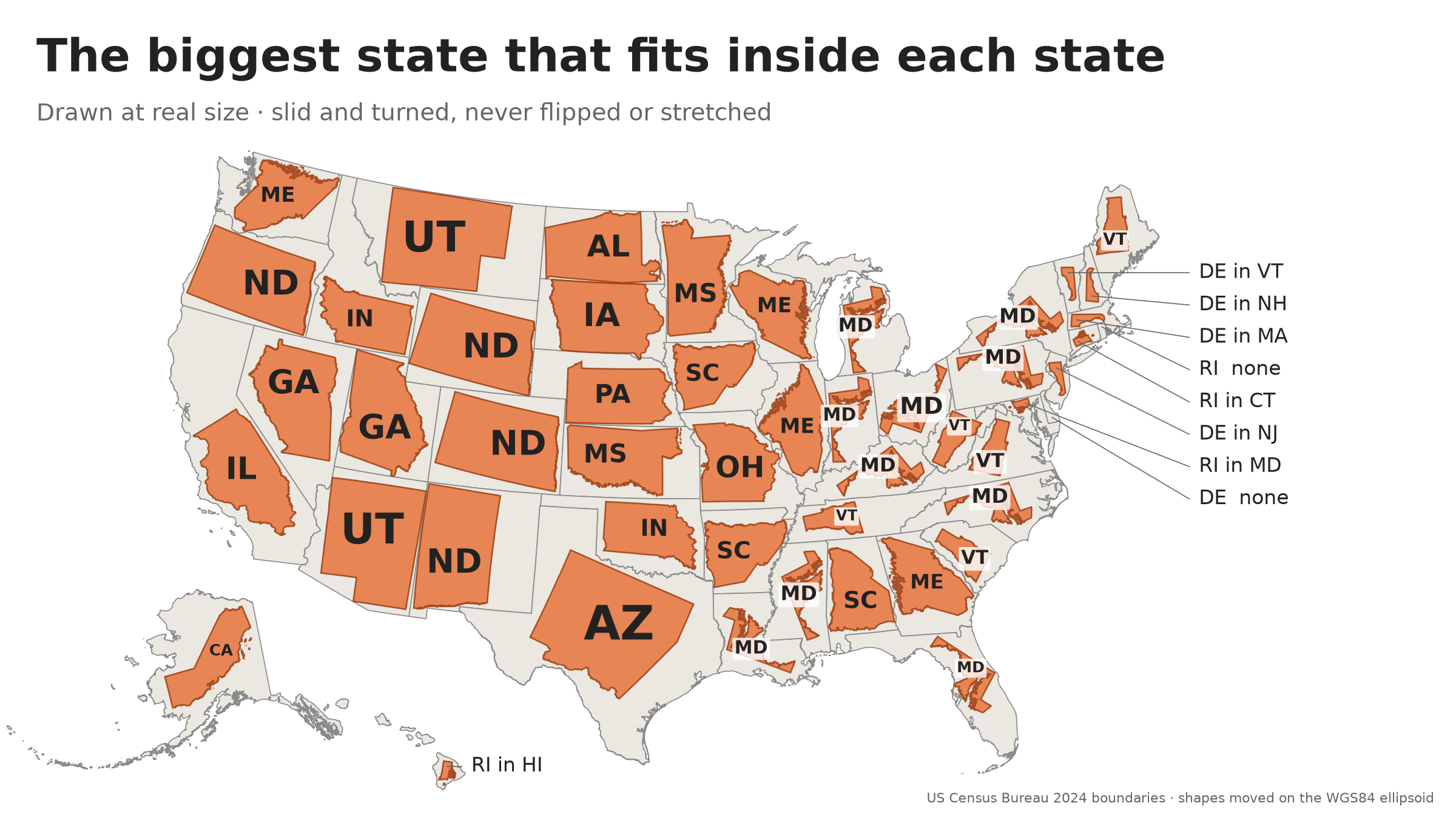
Inside each state, the biggest other state that fits: slid and turned, but never flipped or stretched, with every island landing on land.
- Alaska holds California, with room to spare.
- Texas holds Arizona. New Mexico misses by 0.4%.
- California holds Illinois, with room for a copy 10.7% bigger.
- Maryland is the answer for 10 states.
- The closest call: Indiana inside Iowa, at 99.96% of its size.
- Delaware holds nothing at all.
All the way down
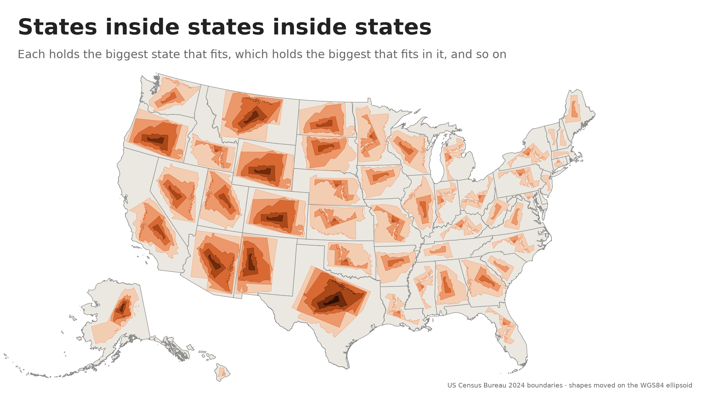
The state inside each state has a state inside it, and so on, until the chain reaches Delaware or Rhode Island. Texas goes deepest, six states down: Arizona, Utah, Georgia, Maine, Vermont and Delaware.
Texas almost fits inside Alaska
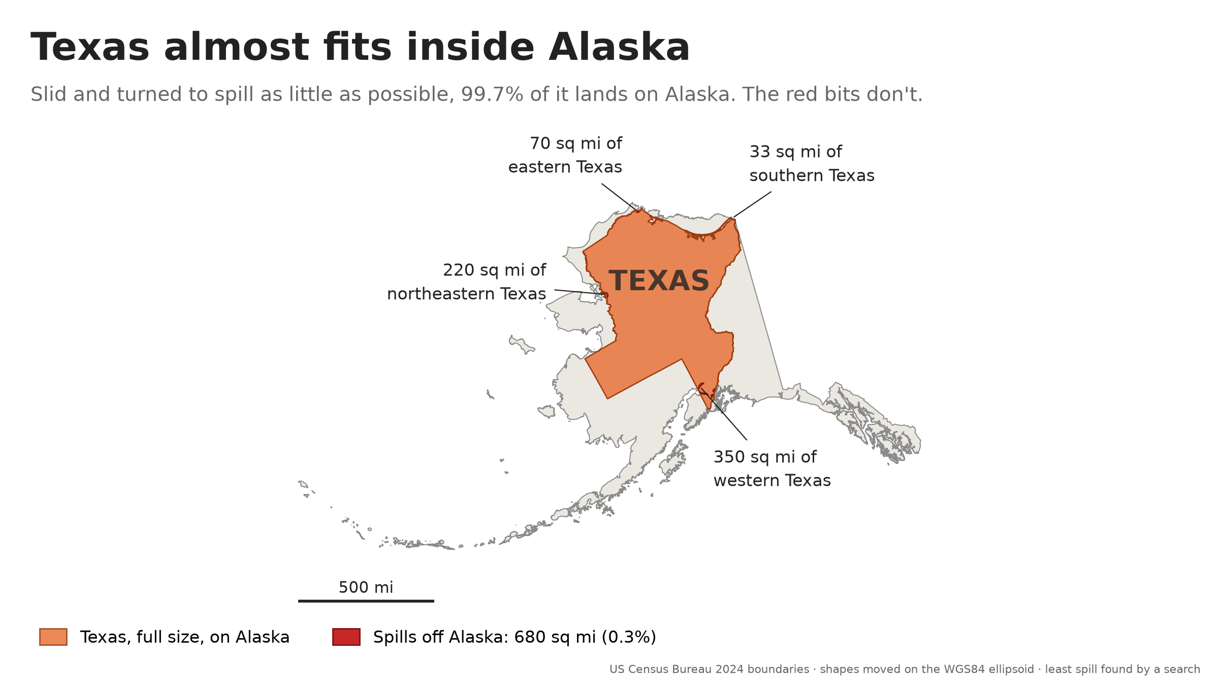
Alaska is more than twice the size of Texas, yet Texas doesn’t quite fit. Turned to spill as little as possible, 99.7% of it lands on Alaska. The 680 square miles that don’t are far West Texas, dipping into Cook Inlet; a stretch of the Red River, in Kotzebue Sound; Sabine Pass, in the Arctic Ocean; and the mouth of the Rio Grande.
Why Wyoming doesn’t fit inside Colorado
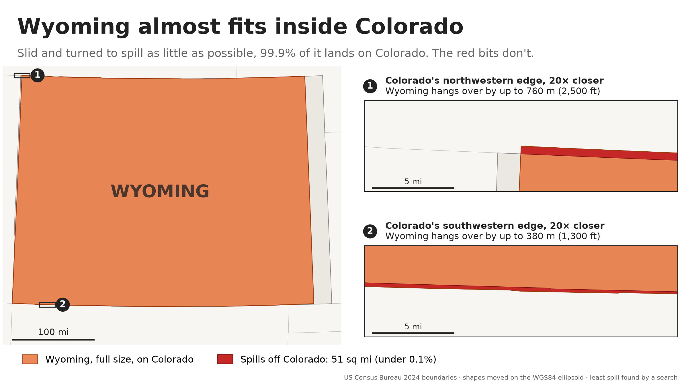
Colorado is bigger and wider, but the two states are the same height: about 276 miles from north to south. Wherever Wyoming’s borders reach a little farther apart than Colorado’s, it hangs over, by up to 2,500 feet, and turning it only makes it taller. Shrunk to 99.7% of its size, it fits.
If their borders ran exactly along lines of latitude, Wyoming would be about 1,000 feet taller, because a degree of latitude is a little longer the farther north you go. But the surveyed borders wander north and south by up to about a mile, which cancels most of that. Big Think explains why Colorado is not a rectangle: its borders are where the surveyors put them, mistakes and all.
The closest call: Indiana in Iowa
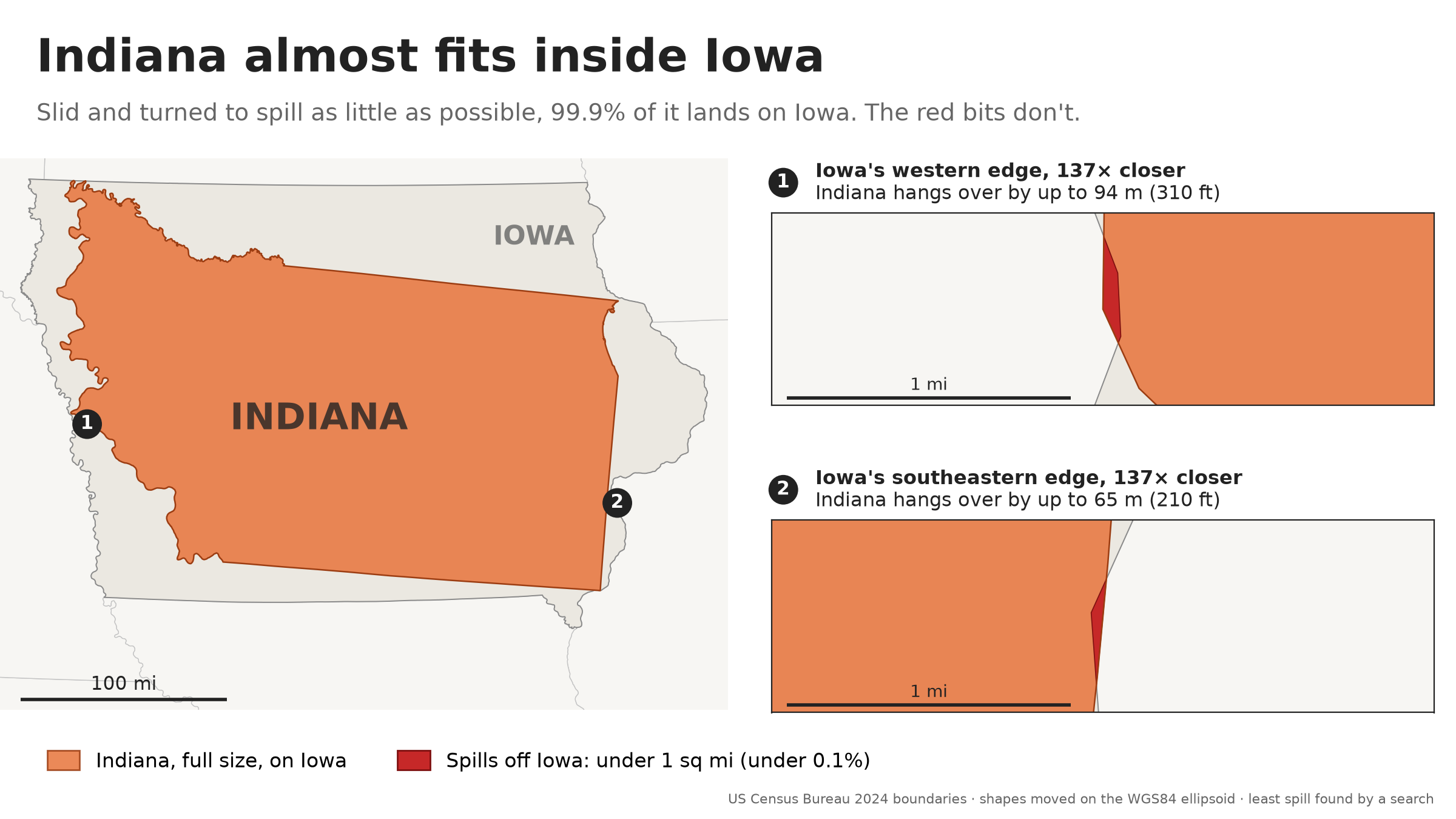
Iowa is more than half again as big as Indiana, but Indiana is long: 324 miles from its southwestern tip to its northeastern corner, and Iowa is at most 314 miles wide. So Indiana lies on a slant, corner to corner, and touches Iowa’s border in four places. Harrison County, Indiana, lands on Harrison County, Iowa, and hangs over the Missouri into Nebraska by 310 feet. The Michigan line hangs over the Mississippi into Illinois by 210 feet. All told, about 15 acres spill. Shrunk to 99.95% of its size, Indiana fits.
Why Delaware holds nothing
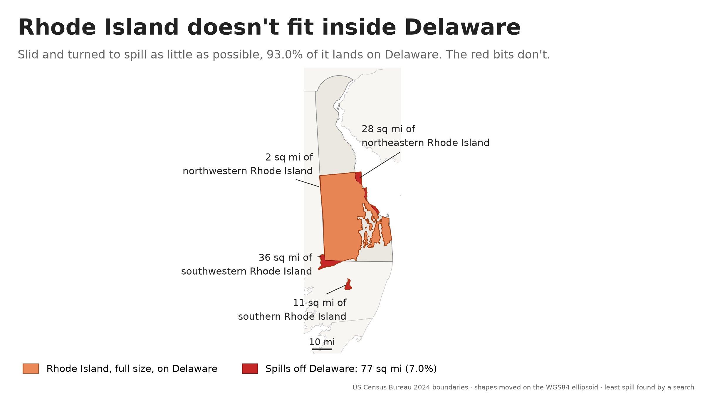
Delaware is nearly twice the size of Rhode Island, but it is only 35 miles across at most, near its southern end, and Delaware Bay narrows it to 18 miles by Dover. Rhode Island is 38 miles across and 49 miles tall, with Block Island 9 miles out to sea. Turned to spill as little as possible, 93.0% of it lands on Delaware. Most of Westerly hangs off Delaware’s southwestern corner into Maryland. Cumberland, Pawtucket and the East Bay towns land in Delaware Bay. Block Island lands in Maryland, 15 miles south of Delaware.
How it’s done
- Boundaries: the Census Bureau’s 2024 cartographic boundary files (1:500,000). A state’s area includes its lakes and rivers.
- Measurements: every length and area is on the WGS84 ellipsoid.
- Single squares: a branch-and-bound search that finds the best square to within a few tens of feet.
- Packing and fitting states: searches, so their answers are the best found, not proven best. Moving a state from one place to another changes distances within it by less than 0.05%.
The README has the details, the caveats and every number.
Make your own
You need uv. The first run downloads the Census boundaries (about 3 MB).
git clone https://github.com/michael-gebis/state-squares.git
cd state-squares
uv run main.py spill TX AK      # full-size Texas on Alaska
uv run main.py nest CA          # the biggest state that fits in California
uv run main.py rotated WI CO    # the biggest squares in these states